Tuesday, 13 August 2013

Digdeguash Estuary

Buried in Foam at Digdeguash Falls

Shoulder high foam churned up by the cascade was the surprising result of a 50 mm deluge the area received two days earlier.  In addition to the foam, there were modest standing waves, not enough to be dangerous, just enough to add a little excitement.
 

We launched an hour before high tide in the gorge under the Route 1 bridge, expecting the flood to carry us effortlessly up the estuary.  But the freshwater outflow from the upper section of the estuary was enough to overcome the powerful flood tide in Passamaquoddy Bay.  Instead of the placid water displayed in the Google Earth image below, we had an uphill battle, fighting a two knot outflow, paddling hard to get around the points, then pausing to catch our breath in the back-eddies.


We had intended to explore the islands in the lower estuary, but didn't allow enough time.  We'll look forward to that on the next visit.  It would have to be a day with light winds.  Passamaquoddy Bay is too big to challenge unless you are an expert kayaker, especially in the prevailing brisk south-westerly's.  The calm conditions in the image below would become three to four foot breaking waves in open water.


If conditions permit, another launch site could be the public beach at Owl's Head.  That would provide an opportunity to enjoy some seafood at Ozzie's, still going strong at their long time location on the old Route 1 at Bethel.


Saturday, 6 October 2012

Deer Island - Challenging Old Sow


The plan was a circumnavigation of Deer Island.  Catch the flood from Lord's Cove through Head Harbour Passage, paddle across the north side of the island at the high, and ride the ebb out through Pendleton Island Passage.  Without the tide it would be a ten hour trip, but this way maybe six, hopefully with no hard paddling.

It was the latest in a grand scheme to collect experiences and turn them into a guide for exploring estuaries and harbours on the Bay of Fundy.  Many kayakers avoid the bay, wary of the 30 foot tides and powerful currents, but there is a way to use them to advantage.  While not a kayaking expert, a thorough understanding of how to take advantage of tides had opened my eyes to the opportunity.  Some of that experience was in kayaks and canoes, but most came from 40 years of coastal cruising under sail, a lot of it in the Bay of Fundy.  


Deer Island was the seventh and most ambitious expedition in the series.  Twenty more lie in the future. 

The circumnavigation went according to plan, but there were moments.  The 20 miles actually took six and a half hours.  I only wish I had more time to explore.  It was really a nutty way to see Deer Island, much too ambitious to take it all in, but the opportunity to use the tides to help make a quick circumnavigation was irresistible. 
 

The Fundy Isles are a paddling paradise; sadly, this trip missed a lot of the magic.  Due to the lack of time, dozens of isolated islands, sheltered coves, and beaches could not be explored, and had to be bypassed.  But I will be back.
The 10:00 am start at Lord's Harbour was an hour after the low.  It put me at Deer Island Point at half tide, smack dab at maximum flood when the current is most dangerous.  Old Sow was raising a ruckus and looked plenty rough.  There was no sign of a single huge vortex, but there were a lot of little ones and some fairly rough water.
 

The strategy was to stay tight against the shore line and paddle around the point in quiet water.  The problem was, the quiet water turned out to be a two knot counter current.  After struggling against it for fifteen minutes it became obvious the current would win.  I would run out of gas before I got through.  That left two options; land on the small beach just to the north-west of the point, which probably meant giving up, or let the counter current sweep me out into the race, which meant tangling with Old Sow.

 
I was confident I could paddle hard enough to stay out of the worst of it, so I picked option two, and worked out of the counter current and into the flood.  It was hairy for sure, at times a little frightening, but at no point did I come close to capsizing.  My kayak was a big Old Town Loon, not the fastest boat afloat, but the stability provided by the extra weight and beam was comforting and very welcome.
 
I expected the current would be linear, and carry me fast and far.  Fat chance of that, it was very turbulent.  Bottom topography is rugged; depths plunge from 75 to 200 metres, then back again.  It was a constant struggle to keep the boat pointed in the right direction; it regularly spun 90 degrees or more.  A better route would be to give the area off the point a much wider berth.  The flood is a lot less turbulent near Campobello Island and the Eastport shore.  That would add a couple of miles to the trip, but the smoother water would repay the extra distance.  You would lose little, if any, time.


Whales and dolphins were absent during the trip, but seals were everywhere.  Most were nervous and kept their distance, but one curious gray swam slowly under my boat, it’s large black eyes tracking my progress through the clear water.

The last two miles up the narrows were into a light northerly which produced a small chop, but once in Passamaquoddy Bay the wind died completely.  A mile to the north-west the slack sails of four small dinghies pulled up on the American shore shone with reflected intensity in the glassy water. 


I paddled along the cliffs and past the bays in warm sunshine, threaded through the giant cages of an aquaculture site, and landed for a short break on a small, isolated beach.  


It took an hour and a half to reach Pendleton Island.  The tide was just beginning to ebb, and gave a fast but quiet ride through the passage.  The water was smooth at that point of the tide, but it would get much rougher the more the tide dropped.  In places I was passing over rocks and shoals.  They have the potential to be dangerous, and once exposed, would narrow the channel and produce a lot of turbulence.  

Past the ferry landing, the final two miles back to Lord's Cove was easy, there was almost no wind and that piece of water has very little current at any state of tide.  At times I had a little with me, at times a little against.
 

It would be a lot of fun to do a two or three day trip around Deer Island.  Stop for the night at B&B's along the way; maybe visit Campobello, and if you remember your passport, even Eastport.  Visit remote beaches and fishing weirs; and chat with the locals, who are colourful, charming, and friendly.  The passages are reasonably narrow so you wouldn't have a problem with wind, and even Passamaquoddy Bay should be doable in the typical summer south-westerly, the wind would be right on the stern.  Can’t wait ‘till next summer.

Monday, 1 October 2012

Dipper Harbour - Estuary and Sea Cliffs


The trip started out as an exploration of the small estuary at the top of Dipper Harbour.  A stream runs into the harbour beside a broad sandy beach.  We launched ninety minutes before the high, and rode the flood under the bridge into the marsh.  The rising tide gradually lifted us until we could see across the meadow, and we noted hundreds of tiny coloured flags that could only be markings from a biological study of marsh vegetation. 


We slowly meandered along with the tide, the stream twisted and turned, and gradually narrowed to barely more than the width of the boats, until it petered out in a tangle of brush and fallen trees in the woods.  By then it was high tide, and we turned to catch the ebb for the ride out.


Back in the harbour we passed three giant fenced aquaculture pens that abutted the shoreline, watched by several curious seals with sleek black heads.  Two of the pens were well weathered, with some posts cut off at the high water mark by ice erosion.  But the last one was almost new, the treated wood was still bright green and could have only been a couple of years old. 


The wharves were lined with idle lobster boats from almost every port on the bay; Yarmouth, Weymouth, Digby, St. Andrew’s.  One advertised Alma Seafood and was registered in Moncton, a port that hasn’t seen a lobster boat in years, if ever.  There are no lobsters in that part of the muddy Peticodiac.


We spoke to a man rowing a pale blue skiff out to one of the boats.  “Wonderful weather today,” we shouted.  “Yes, but rain tomorrow,” the grey haired gent replied.


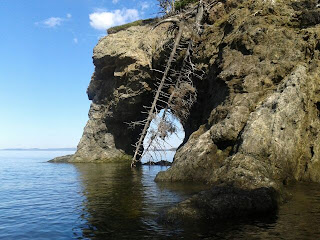
We startled a half dozen herons roosting on the end of the breakwater, and were entertained by calls from a pair of loons a half mile at sea.  Past two pleasant but empty beaches on the western entrance is a line of jagged cliffs.  The cliff rock appears to be primarily metamorphic, and is fractured and heavily eroded with caves and pillars.  At one point a stone eye framed the cliff face beyond.  Wooded debris dotted the shoreline, and rock weed bobbed in the gentle swell.


The end of the cliffs were marked by ancient weir poles, and an eagle led us past the western point.  We could hear breaking water out to sea, but the ocean was far too quiet to account for it.  We quickly realized it was the tide, the ebb from the harbour combined with the flow down the bay was strong enough to break on the ledges off the point, even with only a light south-westerly breeze.  In a stiff wind the seas would be fierce, not for the faint of heart.

On the return we noted the Dipper Harbour station of Eastern Outfitters.  Kayaks and canoes were stacked on trailers ready for exploration, and two sailboats were hauled up beside the sheds.  At one time sailboat charters were a large part of the company’s operation, but in the past few years kayaking has taken over, and the company has expanded to St. Andrew’s and Newfoundland.


We got back to our launch point at half tide, and would not have wanted to be much later.  The top of the harbour dries out completely.  At low tide you would have to pull the kayaks across half a mile of mud.  If you arrive at Dipper at low tide there is still good paddling and lots to explore, but you would have to launch beside the main wharf.

The harbours and the estuaries of the Bay of Fundy are a spectacular place to kayak, but to be safe for the novice, they should only be challenged in fair weather.

Tuesday, 25 September 2012

Kayaking Musquash Harbour


I got the bug to go Monday morning, the water was completely calm and the sunshine was brilliant.  It had to be on the Monday; Tuesday was out because of the forecast 20+ knot winds, plus the high tide was getting late, only occurring well after sunset.  The following two days were forecast to be breezy with showers, and the tides were still out of sync.

We first drove down to Five Fathom Hole.  It was two hours before high tide, and the flood was swirling past the wharf.  Getting downstream to the open part of the harbour would be a good workout, but if you were interested in exploring the Ducks Unlimited marshes upstream, you would have a free ride on a two knot current.  Two hours up with the flood, then another free ride back when the ebb started.

But the launching conditions there were iffy.  There is no ramp, and the only route to the rough, rocky beach was down an overgrown path through a thicket that was soggy from the recent rain.  I tried to push through but turned back when my foot sank deep into the muck in a boggy section.The other possibility was carrying the kayaks down the gangway to the float, but the risk of capsizing in deep, cold water put me off that option.  I already had my dunking for the season back on the Hammond River.


The alternative launch site for Musquash Harbour is Black Beach.  We decided to retrace our drive to Lorneville, then drove down to Colson Cove and on to Black Beach.  The last two kilometres were on a rough gravel road, but the beach itself is beautiful, with black sand as the name suggests.   By then it was almost 600 pm.  It was a lovely evening, too nice to resist, with a light westerly wind and no surf.

We paddled south toward the mouth of Musquash Harbour, led by a Great Blue Heron, past wild cliffs with jagged rock shelves.  Convoluted bright yellow stria framed shallow caves in the sheer limestone face.  We made it past the entrance buoy to the lighthouse before we had to turn back because of the approaching sunset.


The tide had advanced twenty feet up the beach in the short time we were gone.  The sun was down, leaving a blaze of yellow in the western sky.  We just had enough light to secure the kayaks to the car.  It was a really nice area to paddle.  But after a summer without them, the mosquitoes were a nuisance until we got afloat.  They were particularly bad at Five Fathom Hole, probably the result of all the rain we've had in the past couple of weeks.

There are islands in the harbour which need to be explored as well as some interesting beaches and inlets.  A number of features are only accessible at near high tide.  It would take five or six hours to make a complete circuit of the bay, and you would only want to do it in light winds, unless you were well experienced in open water kayaking.  It would be pretty hairy in a stiff southerly, particularly on an ebb tide.  On a satellite photo from Google Maps on such a day, I measured swells that were 140 feet crest to crest, along with obvious wind driven breaking waves that would have to be three or four feet high.

Musquash Harbour is a remarkably isolated bay with almost no human habitation.  Cottages used to dot the waterfront at Black Beach, but they are long gone, and now most of the land is controlled by the province, the Nature Conservancy or Ducks Unlimited. 

One caution bears repeating.  The harbour is three miles long and two miles across, big enough to produce dangerous conditions for the inexperienced.  If the marine forecast calls for winds of over 15 knots, the exposed areas of the harbour are no place for a novice.